
Network Rail produces a series of Route Utilisation Strategies (wikipedia) are recommendations for the future development of train services in specific geographic areas.
It also makes a pretty map.
Network Rail produces a series of Route Utilisation Strategies (wikipedia) are recommendations for the future development of train services in specific geographic areas.
It also makes a pretty map.
![]()
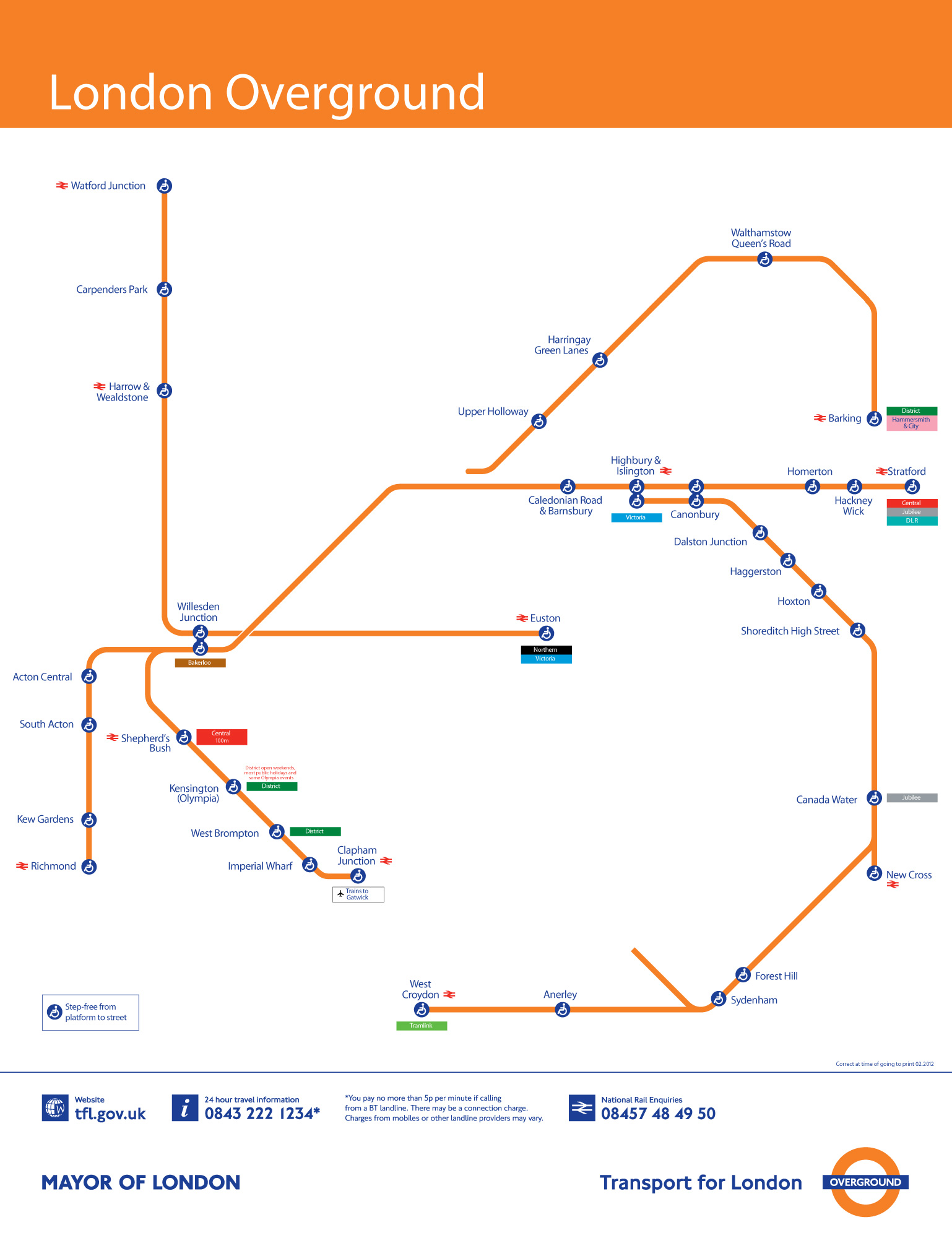
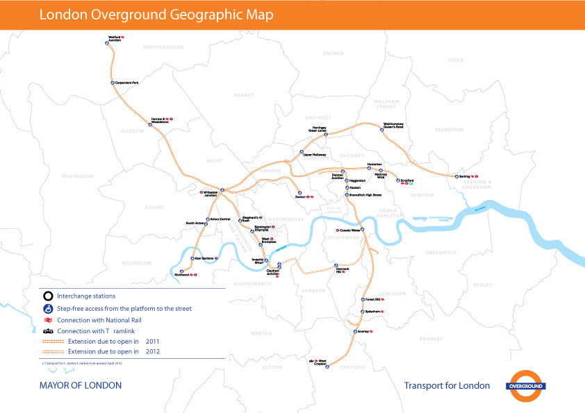
This is the fourth installment of my Accessible Transit Map series. Intended as a replacement map for those with disabilities, this map illustrates which station stops on the Transport for London London Overground system is accessible for those with strollers or with a disability.
London Overground, a suburban rail network in the United Kingdom, is part of the National Rail network linking 20 of London’s 32 boroughs. Starting in 2007 Transport for London consolidated different existing rail concessions and extended new trackage to form the London Overground.
As in previous maps, I have removed all stations which are not handicapped accessible. Maps represent corporeal objects, through convenient fictions – a representation which works for a majority of its users. But where are the maps for the disabled or those require additional accessibility? Wouldn’t the mother with newborn in stroller need a different map then those without the need to lug all the accoutrement’s of childhood? Equally, those in a wheelchair require a map different then one which the walking can use. I decided to rectify the situation by editing the maps of major metropolitan transportation systems, in order to create a map for those who are not represented on the official map.
![]()

![]()
![]()
You can download the London Overground Accessible Transit map below – which comes in two versions – Network and Geographic:
Other Accessible Transit Maps for your perusal:

InterCityAPT, a photo by Mayo Nissen on Flickr.

The Tube is a BBC Two television documentary which looks into the life of those who work and travel on London Underground. It premiered in February, but is just coming to India and is well worth watching to see behind-the-scenes footage of both the infrastructure but also the people who make the Tube go.

Please also see:

Dave Delisle offers this awesome Toronto TTC Subway Map Super Mario 3 (poster of subway map now available) and maps for the Calgary C-Train and Vancouver Skytrain.

News to me: besides having a Congestion Charge zone, London also has a Low Emission Zone
The Low Emission Zone (LEZ) was introduced in 2008 to encourage the most polluting heavy diesel vehicles driving in the Capital to become cleaner. The LEZ covers most of Greater London. To drive within it without paying a daily charge these vehicles must meet certain emissions standards that limit the amount of particulate matter (a type of pollution) coming from their exhausts.
The low emission zone started operating on 4 February 2008 with phased introduction of an increasingly stricter regime until 3 January 2012, and as shown below, covers pretty much all of metropolitan London (the congestion charge zone is shaded orange).

The LEZ is monitored using Automatic Number Plate Reading Cameras to record number plates checking vehicles against the records of the Driver and Vehicle Licensing Agency to enable Transport for London to pursue owners of vehicles for which the charge has not been paid.
It would come as little surprise to my reader that I am a proponent of the London Low Emission Zone; much like the congestion zone, the low emission zone prices (ever so bluntly) an externality: particulate matter which is being dumped into the air by commercial vehicles. A charge both prices in this externality and will drive innovation to reduce vehicle emissions.
I also love the graphic sensibility of the advertising and communication on their website and in collateral, examples shown below.


These blobs represent the extent that you’d be able to travel on public transit in 30 minutes. The 20 maps below were made by Mapnificent, a new website created by Stefan Wehrmeyer that suck in Google Maps-friendly transit data to show just how much of the city you can cover in however much time you want to spend. A handy slider allows you to change your allotted time, and your starting point can be anywhere on the map.
via 30 Minutes on Mass Transit in 20 World Cities – Commute – The Atlantic Cities.
![]()
See also Metropolitana di Roma logo.
