For more than half a century, it has stood out as a singularly vexing flaw of the subway system, a glaring inequity that has frustrated generations of riders and has even puzzled transit officials, who have wondered how the situation ever came to be.
But beginning on Tuesday, once the first travelers make their way between a B train and an uptown No. 6 at Bleecker Street, a daily frustration will have given way to a whimsical remembrance: Here stood New York City’s fussiest subway transfer point, the one that went one way but not the other.
Historically, workers have lived in residential suburbs while commuting to work in the city. For Silicon Valley, however, the situation is reversed: many of the largest technology companies are based in suburbs, but look to recruit younger knowledge workers who are more likely to dwell in the city.
Private mass transit options offered by tech companies such as Apple, Google and Facebook linking San Francisco to Silicon Valley transport approximately 40% of the amount of passengers Caltrain moves everyday. Google alone runs 125 daily trips throughout the city.
I’ve discussed my series of maps called Accessible Transit which removes stations which are not accessible, including systems such as the London Underground, London Overground, New York City Subway. Maps represent corporeal objects, through convenient fictions – a representation which works for a majority of its users. But where are the maps for the disabled or those require additional accessibility? Wouldn’t the mother with newborn in stroller need a different map then those without the need to lug all the accoutrement’s of childhood? Equally, those in a wheelchair require a map different then one which the walking can use. I decided to rectify the situation by editing the maps of major metropolitan transportation systems, in order to create a map for those who are not represented on the official map.
It has come to my attention that Transport for London has a Step Free Tube Guide which illustrates stations where it is possible to get between the platform and street step-free, or change between lines step-free. Stations where this is not possible are shown in a light grey which is nice, but utterly incomprehensible.
Aerial View of air rights development, historic station and train shed as seen from the east with a view looking down H Street. Image courtesy of Akridge/SBA.
The plan comes essentially from the conjunction of two separate issues. One is that way back in 2002, Akridge paid a considerable amount of money for the right to build a platform over a lot of these Union Station tracks. Atop the platform will sit a bunch of buildings, as well as a reconnection of the currently disrupted street grid. That will include a renovation of the existing H Street Bridge, which is currently quite old and in need of some form of replacement.
The money for all this work is separate from the Master Plan proposal and would all come from Akridge. But once this is done, it will become practically impossible to ever move the Union Station tracks.
Amtrak/MARC/VRE’s contention, however, is that moving the tracks would be highly desirable. Why? Because they want to make the platforms wider. Why do they want to do that? For starters, they say the existing 18 foot platforms aren’t compliant with Americans with Disabilities Act and National Fire Protection Association guidelines for safety. New train stations are normally constructed with platforms in the 25-30 foot width range. The practical transportation capacity issue here is that the current platforms are allegedly too narrow to let passengers be getting on/off of the tracks on both sides of the platform simultaneously. Wider platforms allow for simultaneous boarding allow for greater capacity.
Queues of departing Amtrak passengers form a halfhour before boarding begins and routinely extend into the public concourse, blocking flows. Additionally, the tracks and platforms do not comply with modern design standards, including the requirements of the Americans with Disabilities Act (ADA) and the emergency egress standards of life safety codes. The mixing of train servicing activities with passengers – both concentrated at the same end of the platforms – creates circulation bottlenecks that will worsen as passenger volumes increase.
The project’s goals are to increase capacity and reconnect the station with the surrounding neighborhood. Done correctly, and you get Grand Central Terminal, poorly and you get Penn Station. The estimated $7 billion (2012 dollars) is steep for what seems to be a project designed to allow a private developer to maximize profits and to increase capacity. I don’t see why the developer can’t chip in some of the cost of the overall project, as they are the ones who will reap the single biggest reward.
The biggest problem with this project is that for $7 billion you don’t get any additional capacity and speed between city pairs (DC-Baltimore, DC-Philadelphia, DC-NYC) isn’t increased at all. If I was king, I would spend that money on upgrading the Northeast Corridor in order to increase the overall train speed, including improving regional and commuter rail. This is also the problem withe Penn Station renovation plans: they are undoubtably very pretty, but ultimately less useful than making trains go fast.
Union Station Master Plan roof shedUnion Station Master Plan lower concourse planUnion Station Master Plan track planUnion Station Master Plan roof planUnion Station Master Plan section aUnion Station Master Plan section b
OpenPlans, a company which builds open source civic infrastructure, collaborating with the public sector to create technology for more efficient, responsive, and inclusive government, has launched a kickstarter drive to create a Transit App for iOS 6 and Beyond:
With the announcement of iOS version 6, Apple has dropped Google Maps and with it, previously built-in support for travel directions via public transit.
With your support, OpenTripPlanner Mobile, an open source application developed by OpenPlans will put transit back on the iPhone. Initially, we will offer coverage for almost all transit systems in North America (see coverage details below).
The app will also add new features that Google Maps didn’t have, allowing users to combine walking, bikes, bike-share and transit together, finding the fastest and most efficient trips regardless of mode of transportation.
Transit App will is now supporting any transit agency in North America that provides open data in the GTFS format. Hundreds of transit agencies already offer this data – check out the current coverage map.
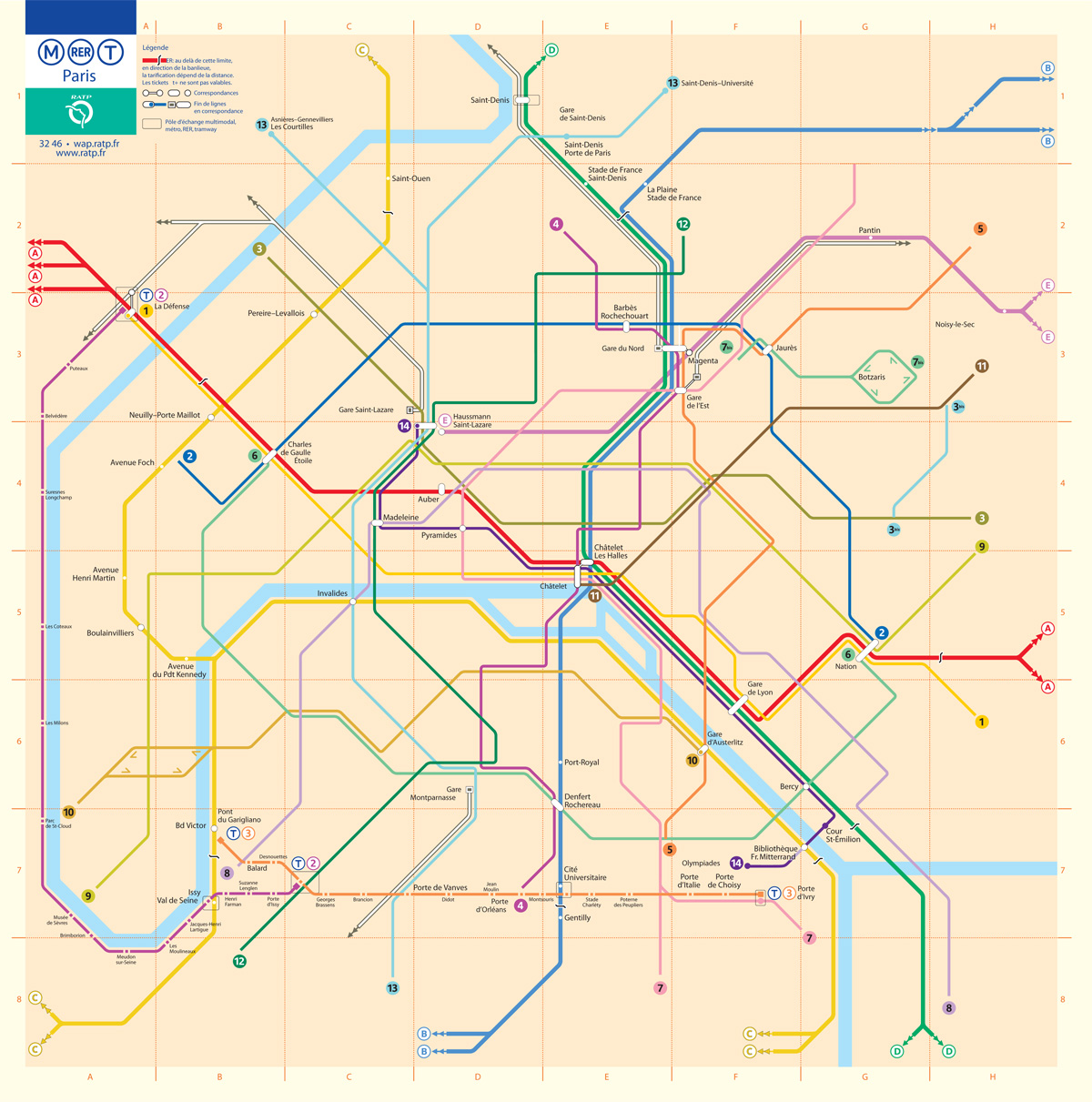
This is the fifth installment of my Accessible Transit Map series. Intended as a replacement map for those with disabilities, this map illustrates which station stops on the Paris Metro are accessible for those with strollers or with a disability. As you can see below, very few stations are accesible in the City of Light:
Opened in 1900, network’s sixteen lines are mostly underground and run to 214 km (133 mi) in length with 301 stations, of which 62 are interchange stations. Just 50 Metro/RER stations within central Paris have elevators and are accessible for wheelchairs or for strollers. Just like London’s Underground the Metro was largely built when accessibility wasn’t a concern; unfortunately the RATP doesn’t match Transport for London’s excellent Accessibility guidelines, offering only a page of platitudes:
Accessibility for persons with reduced mobility. It is the RATP’s ambition to provide every traveller with a transport system suited to his needs from end to end.
As in previous maps, I have removed all stations which are not handicapped accessible. Maps represent corporeal objects, through convenient fictions – a representation which works for a majority of its users. But where are the maps for the disabled or those require additional accessibility? Wouldn’t the mother with newborn in stroller need a different map then those without the need to lug all the accoutrement’s of childhood? Equally, those in a wheelchair require a map different then one which the walking can use. I decided to rectify the situation by editing the maps of major metropolitan transportation systems, in order to create a map for those who are not represented on the official map.
You may download the Accessible Transit Paris Metro map here:
The Hulett Automatic Ore Unloaders once saw wide usage along the Great Lakes unloading bulk ore ships. The Huletts were electrically powered on two parallel tracks along the docks, ordinarily with four railroad tracks in between. A vertical column with a large scoop bucket on the end houses the machine’s operator stationed above the bucket for maximum cargo visibility. The Operator could spin the beam at any angle scooping up to 10 tons of ore per run dumping the load into a moving receiving hopper which ran between the main girders dumping the load into a waiting railroad car.
I vaguely remember seeing the Huletts on Whiskey Island in Cleveland, Ohio when I was a young boy – they were demolished in 2000 after standing idle since 1992 after self-unloading ore ships became the standard on the Great Lakes. So seeing a video of them in operation is amazing: I didn’t realize how big the ore ships were, so the when they strap a front loader to the Hulett bucket and drop it into the ore hold I was dumbfounded.
Below is a video from 1999 from the engine of Amtrak train #44 going under the Huletts on Whiskey Island:
As previously reported, the The Los Angeles County Metropolitan Transportation Authority (Metro) Board of Directors voted to approve a contract with Los Angeles-based Gruen Associates in association with Grimshaw Architects of London for the creation of a master plan for the historic Union Station and its surrounding 40 acres.
Metro anticipates signing the contract this summer with the goal of having the master plan completed within 18 to 24 months, or summer 2014. Gruen/Grimshaw has broughttogether a large team of specialist firms from preservation experts to sustainability and technicalconsultants to collaborate on the plan which will be adopted after an approval from the MetroBoard.
The above “vision board” – a requirement of the RFP created by six different architecture firms – shouldn’t be taken seriously, as LA Metro’s own release states that “while there will be no detailed architectural design involved with this master plan, Grimshaw is expected to bring architectural vision to the process.” Hopefully this won’t turn into another World Trade moment where the master planner is kicked off the project. I have great respect for Grimshaw and their work, and hope they can help knit the center of Los Angeles back together.
For all 51 metro areas with a million or more people, cities as a whole grew by 1.1% from 2010 to 2011, while suburbs increased 0.9%. That’s a big change from the last decade, in which suburbs expanded at triple the rate of cities.
“This can really be seen as a milestone,” said William Frey, a Brookings Institution demographer who analyzed the census data to be released Thursday. “What’s significant about it is that it’s pervasive across the country.”
Myers and SungHo Ryu argue [in Aging Baby Boomers and the Generational Housing Bubble: Foresight and Mitigation of an Epic Transition – ed.] that the future population and age structure will lead to differences between age and home buying and selling. The aging, retirement and lifestyle patterns of the 76 million baby boomers will likely shape U.S. housing markets and trends for decades ahead. They conclude that there will be an oversupply of homes offered for sale by aging baby boomers – many of which may not be of the housing type that young buyers want. The researchers raise the idea that where decline once occurred as housing moved from the central city to the suburbs, it may now be reversed as the suburbs will see surpluses of large-lot single-family housing.
The suburbs have long enjoyed subsidies many magnitudes greater than central cities, which is a travesty when you rank the productivity and economic output of denser central cities to suburbs. It isn’t even close according to the New York Fed in Management of Large City Regions: Designing Efficient Metropolitan Fiscal Policies:
Among the 363 MSAs [ed. what’s an MSA?] defined by OMB, just fifty had populations over one million. Yet the output of these fifty cities accounted for nearly two-thirds (65%) of national GDP of $11.5 trillion (in $2001).
I can’t talk about others whom champion cities, but I think there is a place for hyper dense cities such as Manhattan, merely dense cities such as Brooklyn or even Boston and the suburbs. But the fact that the suburbs are given subsidies over and above cities is just wrong from a moral point of view (unless you are buying land in West Virginia as future oceanfront property) but also from an economic point of view. Investing in multimodal transportation – high speed rail and local mass transit – not only makes sense from an economic viewpoint, but increases individual liberty by allowing people to chose to walk, take the train or buy and drive their personal car.
Greater Greater Washington has a great article about the Metro’s 17-foot long “experimental station” (photo above) built in 1968 to test the design of Chicago architect Harry Weese.
Prior to construction, the NCTA erected, on a site adjacent to the future Rhode Island Avenue station, a partial full-scale mock-up of a cross section of a typical below-grade vaulted train room, complete with a segment of a full-size train car. The model measured 64 feet (19.5 meters) in width, 30 feet (9.1 meters) in height, and 17 feet (5.2 meters) in length and was used to study and test various components of the design and construction of the system.
I love the Washington Metro stations: they have aged very well in the last 40 years and are an iconic statement which is instantly recognizable as being DC.


