Step-Free London Underground Map

I’ve discussed my series of maps called Accessible Transit which removes stations which are not accessible, including systems such as the London Underground, London Overground, New York City Subway. Maps represent corporeal objects, through convenient fictions – a representation which works for a majority of its users. But where are the maps for the disabled or those require additional accessibility? Wouldn’t the mother with newborn in stroller need a different map then those without the need to lug all the accoutrement’s of childhood? Equally, those in a wheelchair require a map different then one which the walking can use. I decided to rectify the situation by editing the maps of major metropolitan transportation systems, in order to create a map for those who are not represented on the official map.

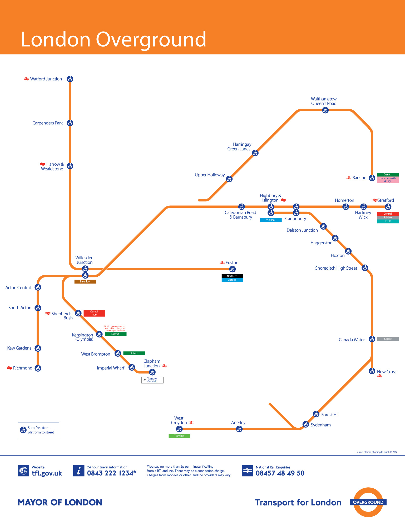
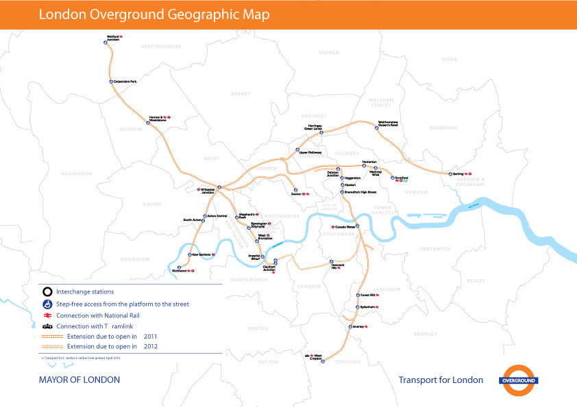
It has come to my attention that Transport for London has a Step Free Tube Guide which illustrates stations where it is possible to get between the platform and street step-free, or change between lines step-free. Stations where this is not possible are shown in a light grey which is nice, but utterly incomprehensible.

Kickstarter: Transit App for iOS 6

OpenPlans, a company which builds open source civic infrastructure, collaborating with the public sector to create technology for more efficient, responsive, and inclusive government, has launched a kickstarter drive to create a Transit App for iOS 6 and Beyond:

With the announcement of iOS version 6, Apple has dropped Google Maps and with it, previously built-in support for travel directions via public transit.

With your support, OpenTripPlanner Mobile, an open source application developed by OpenPlans will put transit back on the iPhone. Initially, we will offer coverage for almost all transit systems in North America (see coverage details below).

The app will also add new features that Google Maps didn’t have, allowing users to combine walking, bikes, bike-share and transit together, finding the fastest and most efficient trips regardless of mode of transportation.

Transit App will is now supporting any transit agency in North America that provides open data in the GTFS format. Hundreds of transit agencies already offer this data – check out the current coverage map.

Accessible Transit: Paris Metro

This is the fifth installment of my Accessible Transit Map series. Intended as a replacement map for those with disabilities, this map illustrates which station stops on the Paris Metro are accessible for those with strollers or with a disability. As you can see below, very few stations are accesible in the City of Light:

Opened in 1900, network’s sixteen lines are mostly underground and run to 214 km (133 mi) in length with 301 stations, of which 62 are interchange stations. Just 50 Metro/RER stations within central Paris have elevators and are accessible for wheelchairs or for strollers. Just like London’s Underground the Metro was largely built when accessibility wasn’t a concern; unfortunately the RATP doesn’t match Transport for London’s excellent Accessibility guidelines, offering only a page of platitudes:

Accessibility for persons with reduced mobility. It is the RATP’s ambition to provide every traveller with a transport system suited to his needs from end to end.

As in previous maps, I have removed all stations which are not handicapped accessible. Maps represent corporeal objects, through convenient fictions – a representation which works for a majority of its users. But where are the maps for the disabled or those require additional accessibility? Wouldn’t the mother with newborn in stroller need a different map then those without the need to lug all the accoutrement’s of childhood? Equally, those in a wheelchair require a map different then one which the walking can use. I decided to rectify the situation by editing the maps of major metropolitan transportation systems, in order to create a map for those who are not represented on the official map.

You may download the Accessible Transit Paris Metro map here:

Other Accessible Transit Maps for your perusal:

Washington DC’s 17 foot Long Station Prototype Mockup

Greater Greater Washington has a great article about the Metro’s 17-foot long “experimental station” (photo above) built in 1968 to test the design of Chicago architect Harry Weese.

Architecture Week has a quick overview of the station mockup, and the whole history is worth your read:

Prior to construction, the NCTA erected, on a site adjacent to the future Rhode Island Avenue station, a partial full-scale mock-up of a cross section of a typical below-grade vaulted train room, complete with a segment of a full-size train car. The model measured 64 feet (19.5 meters) in width, 30 feet (9.1 meters) in height, and 17 feet (5.2 meters) in length and was used to study and test various components of the design and construction of the system.

I love the Washington Metro stations: they have aged very well in the last 40 years and are an iconic statement which is instantly recognizable as being DC.

L'Enfant Station

DC Metro

Coffer

Coffer

Accessible Transit: London Overground

This is the fourth installment of my Accessible Transit Map series. Intended as a replacement map for those with disabilities, this map illustrates which station stops on the Transport for London London Overground system is accessible for those with strollers or with a disability.

London Overground, a suburban rail network in the United Kingdom, is part of the National Rail network linking 20 of London’s 32 boroughs. Starting in 2007 Transport for London consolidated different existing rail concessions and extended new trackage to form the London Overground.

As in previous maps, I have removed all stations which are not handicapped accessible. Maps represent corporeal objects, through convenient fictions – a representation which works for a majority of its users. But where are the maps for the disabled or those require additional accessibility? Wouldn’t the mother with newborn in stroller need a different map then those without the need to lug all the accoutrement’s of childhood? Equally, those in a wheelchair require a map different then one which the walking can use. I decided to rectify the situation by editing the maps of major metropolitan transportation systems, in order to create a map for those who are not represented on the official map.

You can download the London Overground Accessible Transit map below – which comes in two versions – Network and Geographic:

Other Accessible Transit Maps for your perusal:

30 Minutes on Mass Transit in 20 World Cities

30 Minute Transit, Washington DC

These blobs represent the extent that you’d be able to travel on public transit in 30 minutes. The 20 maps below were made by Mapnificent, a new website created by Stefan Wehrmeyer that suck in Google Maps-friendly transit data to show just how much of the city you can cover in however much time you want to spend. A handy slider allows you to change your allotted time, and your starting point can be anywhere on the map.

via 30 Minutes on Mass Transit in 20 World Cities – Commute – The Atlantic Cities.