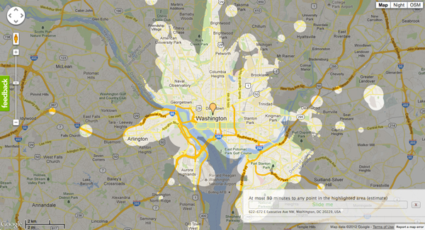
These blobs represent the extent that you’d be able to travel on public transit in 30 minutes. The 20 maps below were made by Mapnificent, a new website created by Stefan Wehrmeyer that suck in Google Maps-friendly transit data to show just how much of the city you can cover in however much time you want to spend. A handy slider allows you to change your allotted time, and your starting point can be anywhere on the map.
via 30 Minutes on Mass Transit in 20 World Cities – Commute – The Atlantic Cities.
Tag: infrastructure
Cartography Police
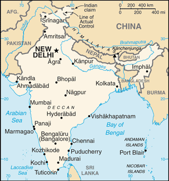
On the front page of the Times of India, is the following piece, US state department shows PoK as part of Pakistan:
At a time when incorrect India maps are getting the goat of not just the government but also journalists, there is even more alarming news for India’s strategic community. The official website of US department of state, which handles foreign relations of the country, shows PoK as part of Pakistan, notwithstanding India’s claim over the region.
In the case of India, however, the map differs from the official Indian map in that it completely ignores India’s claim over PoK by not even acknowledging its disputed status.
…
“It shows a distinct pro-Pakistan cartographic tilt that is inconsistent with the UN projection of the entire PoK (including Gilgit-Baltistan) as disputed,” strategic affairs expert Brahma Chellaney said.
The offending map is nary to be found on the State website (but is reprinted above and at the CIA Factbook on India), so it undoubtably has been seen as a diplomatic slight and is being fixed. If you want to learn more about how and what this is all about, check out this abridged Wikipedia list:
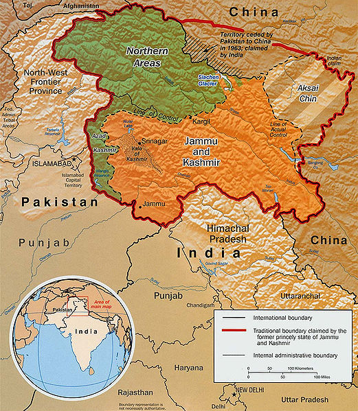
- Indo-Pakistani War of 1947 – Pakistan acquires two-fifths of Kashmir, Line of Control established
- Sino-Indian War of 1962 Line of Actual Control established
- Indo-Pakistani War of 1965
- Indo-Pakistani War of 1971 – Bangladesh is formed (Pakistan effectively loses half their population)
The Yoruba say that lines hove power. “This country has become civilized” literally means “This earth has lines upon its face.” Ilàjú in Yoruba means both “Civilization” and face with lined marks. The line on a body is the city, the polis, the civilization.
I can understand, if not completely internalize the sentiment of this article. I don’t want to step into this longstanding 64+ year long argument, especially after a colleague chastised me when I was drawing the map of India and left off the PoK. My colleague yelled, “You left the crown off the top! Are you some kind of Pakistani cartographer?” While it was good natured, the admonishment stayed with me, revealing a topic which is better left not discussed as a foreign visitor.
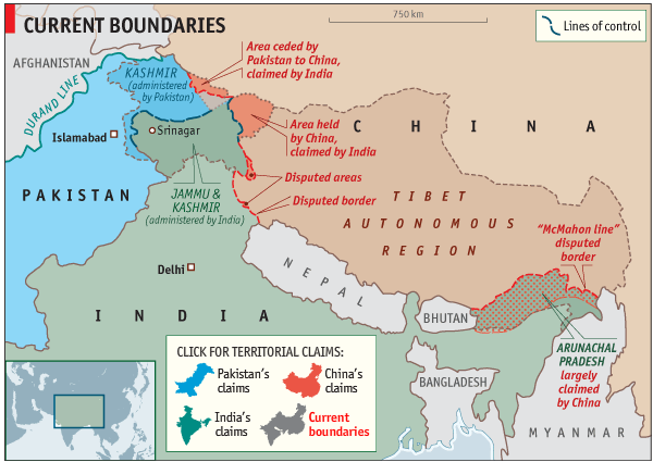
Note that this isn’t just about lines on a map, even if this week’s Economist has been censored due to showing the disputed area of Kashmir (see also Fantasy frontiers which explains the territorial claims). Rather there are both nationalistic reasons for disputing the borders, but also physical reasons: natural resources. Don’t miss the epic Economist article, Unquenchable thirst, A growing rivalry between India, Pakistan and China over the region’s great rivers may be threatening South Asia’s peace:
The river swirls away, white-crested and silt-laden, racing to the nearby border with Pakistan. But there Baglihar is a source of bitterness. Pakistanis cite it as typical of an intensifying Indian threat to their existence, a conspiracy to divert, withhold or misuse precious water that is rightfully theirs. Officials in Islamabad and diplomats abroad are primed to grumble about it. Pakistan’s most powerful man, the head of the armed forces, General Ashfaq Kayani, cites water to justify his “India-centric” military stance.
Others take it further. “Water is the latest battle cry for jihadis,” says B.G. Verghese, an Indian writer. “They shout that water must flow, or blood must flow.” Lashkar-e-Taiba, a Pakistani terror group, likes to threaten to blow up India’s dams. Last year a Pakistani extremist, Abdur Rehman Makki, told a rally that if India were to “block Pakistan’s waters, we will let loose a river of blood.”
Q1 2009 Current Major Transportation Capital Projects in New York City
Over the weekend I was in a conversation discussing the different transportation capital improvements currently in process in the New York City Region. Below is a current list as of the First Quarter (Q1) of 2009 for all major capital improvements by the MTA and the Port Authority. If you step back, there are an amazing amount of infrastructure and transportation capital projects occurring in the NYC Region. Note: capital campaigns are separately funded from the operational budgets. The current MTA budgetary issues are operating, not capital. But without additional funding, in both operating and capital budgets, the current level of service the MTA provides will degrade back in to the 1970’s level of service.
Current Major Transportation Capital Projects in New York City:
South Ferry Terminal
- Status: Grand Opening Today
- New York City Transit (MTA)
- Budget – $530 million (Federal Transit Administration)
The South Ferry Terminal is a new station of the 1 Line in Lower Manhattan replacing the original turn-back loop which can only fit the first five cars. This project was slated to open in early 2009 but has been plagued with accessibility issues and other performance issues.
Today is the official Grand Opening
Second Avenue Subway
- Status: Phase 1 est. completion 2015
- New York City Transit (MTA)
- Current Budget – $337 million (Phase One only)
The first new subway line in over 30 years, the Second Avenue Subway is halfway through Phase One. Phase One includes new tunnels from 105th Street and Second Avenue to 63rd Street and Third Avenue, with new stations along Second Avenue at 96th, 86th and 72nd Streets. Once Phase One is complete, the Q train will be extended from its current terminus at Lex/63rd Street up Second Avenue stopping at 72nd, 86th, and 96th Streets. Phase Two (125th St. to 96th St.) is scheduled for 2014-2017, Phase Three (63rd St. to Houston St.) for 2015-2018 and Phase Four (Houston St. to Hanover Sqr.) 2017-2020. The main reason the project’s schedule is so long is the lack of secured funding.
7 Line Extension
- Status: tunnel boring began – est. completion 2010
- New York City Transit (MTA)
- Extension of the 7 Line west to Tenth Avenue then South to a new 34th Street Station.
- Current Budget – $2 billion (financed by NYC bonds)
Extension of the 7 Line to service the existing Jacob K. Javits Convention Center (the extension was originally proposed for the failed 2012 Olympic Bid and the failed NY Jets Stadium at Hudson Yards). Currently, there is a tunnel boring machine running north from 29th St/11th Ave.
East Side Access
- Status: Tunelling
- Project Completion 2015
- Long Island Railroad (MTA)
- Current Budget – $6.3 billion
East Side Access will bring Long Island Railroad service to Grand Central Terminal using the existing 63rd Street Tunnels and two new sets of tunnels connecting both ends of the 63rd Street Tunnels. One set of approach tunnels pass under the existing Sunnyside Yards while the other tunnels pass under the existing Metro North Tunnels on Park Avenue and terminate at Grand Central. Project is estimated to be complete in 2015.
Fulton Street Transit Center Project
- Status: Unknown
- New York City Transit (MTA)
- Linking 12 Downtown Subway Lines
- Current Budget – $1.4 billion ($497 million from HR-1 Stimulus Package)
Stations served by the 2, 3, 4, 5, A, C, E, J, M, R, W and Z services will be rehabilitated and connected via an east-west underground passageway designed by Grimshaw Architects. A high-visibility Transit Center will be constructed, with entrances on Broadway between Fulton Street and John Street. The station will be handicapped accessible.
World Trade Center Transportation Complex
- Status: Construction of subsurface tunnels
- Port Authority of New York & New Jersey
- New Commuter Rail Station
- Current Budget – $3.2 billion
Designed by Santiago Calatrava, this transit center will house the terminus for the PATH trains at World Trade. Initial foundations are complete and sections of the structure have been erected.
Access to the Region’s Core
- Status: initial contracts
- Port Authority of New York & New Jersey
- New commuter tunnels under the Hudson River to Penn Station
- Current Budget – $8.7 billion (NJ State $2.7 billion, PANYNJ $3 billion, $3 Federal)
ARC is a new two-tunnel (single track) project creating a single-seat trap for New Jersey Transit riders to Penn Station doubling the current capacity. Creation of two new Hudson River tunnels and new deep-cavity terminal connected to Penn Station. The first contracts were announced last week.
Moynihan Station
- Status: unknown
- Amtrak, New Jersey Transit
This project has a particular place in my heart, a project which typifies large capital construction in New York City. Last week Senator Schumer was seeking federal funding for Moynihan Station with Amtrak moving into the future Moynihan Station. Currently the project is in negotiations between the City, State, Federal governments and the two developers involved in the project Related and Vornado. Keep wishing.
Thursday, Snow Again?, Links
- Access to the Region’s Core is Approved and is waiting for funding
- Stimulus draft released; $30B for highways vs. $10B for transit
- OMA’s Zeekracht North Sea wind farm masterplan offers promise of European energy independence
- The Most Gerrymandered Congressional Districts
- Waiting outside the MTA hearing
- By Request: A National Grid?
- Seminal Store Design: SITE Best Stores – you! Watch! Now!
Shovel Ready NY Region Transit List
The New York & New Jersey Congressional Delegations should be advocating these shovel ready
infrastructure projects for the stimulus bill:
- Second Avenue Subway (MTA SAS Page)
- Access to the Regions Core
- East Side Access
- Moynihan Station
- Cross Harbor Movement Project
- Stewart Express
If any of the above projects aren’t on the list, our Delegation isn’t trying too hard.
BQE Figure-Ground


Eisenhower Interstate System

Interstate Infrastructure
Ryan takes issue with Greg Mankiw’s contention that infrastructure is a local issue. Besides the Federal Governments Constitutional purview of Interstate Commerce, Mankiw is also wrong because political boundaries are often arbitrary, capricious or outdated.
Take the greater New York City area, which is composed of three states and at the very least 16 counties. As I’ve previously wrote about in The 51st State – State of New York City and Comparing NYC & Washington DC, it is more logical to think of the greater NYC area using both OMB and Census Bureau’s Metropolitan and Micropolitan Statistical Area than existing political boundaries. Currently the Census Bureau counts over 170 MSA’s ranging from Youngstown-Warren-Boardman, OH-PA to Louisville-Jefferson County, KY-IN to Albany-Schenectady-Troy, NY. You can even download a map of Metropolitan and Micropolitan Statistical Areas of the United States and Puerto Rico, December 2006.
All of this is to reinforce that while infrastructure does have a local use component, the funding, design and policy aims of the greater American infrastructure network is decidedly Federal in nature and needs to be part of the larger political process.
Access to the Region’s Core in NY Times

I’ve written about Access to the Region’s Core – the new two-track rail tunnel under the Hudson River, but today The New York Times has an extensive write-up of the project, Tunnel Milestone, and More to Come:
But the tunnels reached their peak-hour capacity in 2003 when the Secaucus transfer hub opened. So New Jersey Transit and the Port Authority of New York and New Jersey are planning to spend $7.6 billion to build a second set that will more than double, to 48 an hour, the number of trains that can traverse the Hudson.
The project, called Access to the Region’s Core, or ARC, is in some ways as monumental as the first tunnels, which cost the Pennsylvania Railroad $111 million, a price tag that included the old Pennsylvania Station and four other tunnels under the East River. (It’s about $2.5 billion now when accounting for inflation.)
If federal approval is given this summer and grants are secured later this year, construction will begin in early 2009 and take eight years. Contractors will deploy boring machines the length of football fields to drill through granite, schist and other materials, use laser-guided satellite signals to pinpoint their location, and carve a path under 34th Street so wide that commuters will be able to walk underground to 14 subway lines, and to PATH, Amtrak, New Jersey Transit and Long Island Rail Road trains.
Also see a multimedia explanation about the two different tunnels and what the Future Stewart Express Might Look Like which would utilize the new tunnels.
What the Future Stewart Express Might Look Like

I’ve discussed the Port Authority’s new Hudson tunnel project for Stewart International Airport before but there is a new, if fluffy, article in the WSJ, Sending Fliers Up the River To Ease Traffic:
Stewart Airport, an abandoned Air Force base 60 miles up the Hudson River from Manhattan, is being transformed into a fourth airport for the Port Authority of New York and New Jersey, New York’s airport operator.
…
Chicago proposed creating a third airport in Peotone, Ill., but airlines fought the proposal vehemently. Los Angeles has pumped lots of money into Palmdale, Calif., hoping to make it a reliever for the congested LA Basin, but so far only United Airlines is offering limited, subsidized service.
The idea has worked elsewhere. London’s satellite airports in the countryside have been growing rapidly, driven largely by discounters easyJet and Ryanair. Boston is ringed by several competing airports with commercial service, from big operations at Providence, R.I., and Manchester, N.H., which have become major destinations for Southwest Airlines and others, to fledgling development at Worcester, Mass., and former military bases in Portsmouth, N.H., and Bedford, Mass. Skybus now flies to Portsmouth, formerly Pease Air Force Base about 44 miles from Boston.
What is missing in this cheerleading is investigating why exactly the the airports noted above work. The difference between successful reliever airports, moderately successful reliever airports and unsuccessful reliever airports has everything to do with transportation. London’s Gatwick, Stansted and Luton airports are all successful because they have direct rail links to Central London which takes 30 minutes (Gatwick) to 45 minutes (Luton & Stansted). Additionally, for anyone who has repeatedly flown in and out of London’s Heathrow airport, the chance at flying to a different airport and take a similarly long train to centre London is greatly appealing.1 The Boston airports, Providence, Manchester & Portsmouth all have direct bus connections with Boston’s South Station with an under-hour trip.
For Stewart to become a fully-functioning reliever airport, two things must happen: the three New York airports, La Guardia JFK & Newark must continue their slide into chaos and delay, thus making the trip to Stewart palatable; or, a dedicated single-seat (and quick – a trip of no more then 45 minutes) train service from Stewart-to-Penn Station must be built. Both have costs: time and lost revenue for the airlines, and the cost of connecting Stewart with Penn Station.
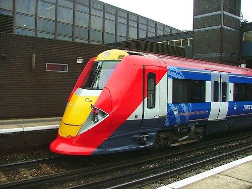
Gatwick Express photo by Les Chatfield
Here is how it could be done:
It currently takes 1 hour 33 minutes from Salisbury Mills/Cornwall, the closest Metro-North station, to NY Penn Station with a change at Secaucus Junction.2 The future Stewart Express, would not only need to connect from Salisbury Mills/Cornwall. Suffice to say, this travel time would be trimmed by the Access to the Region’s Core tunnel project, but one problem which will hamper this line is the existing two track right of way. This will need to be upgraded to a minimum three track, but realistically, four track ROW in order to safely operate the Stewart Express to and from Penn Station. An additional staging/repair yard would need to be located somewhere in the system for the additional Stewart Express trains. This is all predicated on being able to purchase, or use the State’s power of eminent domain, to acquire the additional ROW to access Stewart and appropriating the capital expenditure required to build and upgrade the line.

ROW of the mythical Stewart Express
All of this adds up to a very long-term project, which in today’s political climate doesn’t have a great deal of chance without a strong support throughout all levels of government.
- I deeply love waiting in the cattle pen-like security line, or the three different security checks LHR presents current travellers ↩
- Current riders travel 69 minutes on a local train from Salisbury Mills/Cornwall to Secaucus Junction, wait approximately 10 minutes and then take a NJ Transit train an additional 15 minute NY Penn Station. See complete timetable (pdf) ↩
