Metrofocus has a great new video on the MTA’s Subways, Bridges and Tunnels Through the Eyes of an MTA Photographer, concentrating on the big capital projects: Second Avenue Subway, 7 Line extension, and East Side Access.
Tag: MTA
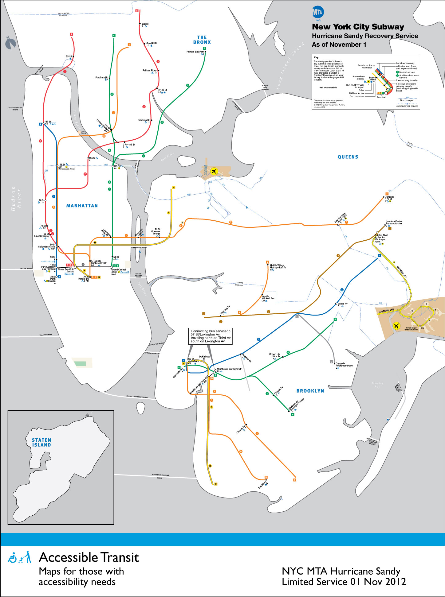
Accessible Transit – NYC Subway Hurricane Sandy Service
![]()
With the extensive damage wrought by Hurricane Sandy on the Northeast it is unsurprising that the New York Subway has been especially hard hit. Many of the underground river crossings were fully flooded, but luckily most of the rolling stock has been spared and all of the large capital projects (East Side Access, 7th Line extension, and the Second Avenue Subway) have received little to no damage.
What hasn’t been spared are people’s commute – which has been brutal due to the lack of power below 34th Street. This means that even if all cross river tunnels were dry and open for operation there would be no service due to power loss. Below is the Accessible Transit map for the New York City Subway during partial shutdown. This is the sixth installment of my Accessible Transit Map series – an unofficial map, not sanctioned by the MTA or NYCTA. As in previous maps, I have removed all stations which are not handicapped accessible.
Maps represent corporeal objects, through convenient fictions; a representation which works for a majority of its users. But where are the maps for the disabled or those require additional accessibility? Wouldn’t the mother with newborn in stroller need a different map then those without the need to lug all the accoutrement’s of childhood? Equally, those in a wheelchair require a map different then one which the walking can use. I decided to rectify the situation by editing the maps of major metropolitan transportation systems, in order to create a map for those who are not represented on the official map.
Midtown Detail

Overall Map
![]()
You may download the Accessible Transit NYC Subway Hurricane Sandy Service map here:
- Accessible Transit NYC Subway Hurricane Sandy Service – jpg version
- Accessible Transit NYC Subway Hurricane Sandy Service – pdf version
Other Accessible Transit Maps for your perusal:
Let the Federal Reserve buy up MTA Infrastructure Bonds

The most obvious source of funding for these projects would be for the Federal Reserve to purchase public infrastructure bonds instead of the $40 billion a month of mortgage-backed securities it has been buying. The housing market is important, and keeping mortgage rates low is useful, but investing in public infrastructure is much more important for the nation now. This approach would require a small legislative change to Section 14(b) of the Federal Reserve Act, which currently only allows the Fed to purchase of municipal bonds that mature in six months or less. These infrastructure bonds must be issued with maturities extending from 30 to 50 years, because the assets they fund will last at least that long. In two months, the Fed could buy $80 billion in infrastructure bonds. That would build some very important public infrastructure.
– Can the Port Authority and MTA afford repairs after Sandy?
Bleecker Street Station finally gets a two-way transfer

For more than half a century, it has stood out as a singularly vexing flaw of the subway system, a glaring inequity that has frustrated generations of riders and has even puzzled transit officials, who have wondered how the situation ever came to be.
But beginning on Tuesday, once the first travelers make their way between a B train and an uptown No. 6 at Bleecker Street, a daily frustration will have given way to a whimsical remembrance: Here stood New York City’s fussiest subway transfer point, the one that went one way but not the other.
via Vexing Flaw in the Subway Is Finally Corrected – NYTimes.com.
Tunneling Below Second Avenue

The New York Times Magazine has an article about the Tunneling Below Second Avenue:
“Geology defines the way you drive the tunnel,” Mukherjee said. The bedrock below Second Avenue and for much of the rest of Manhattan is schist — a hard, gray black rock shot through with sheets of glittery mica. Some 500 million years ago, Manhattan was a continental coastline that collided with a group of volcanic islands known as the Taconic arc. That crash crumpled layers of mud, sand and lava into schist, lending it an inconsistent structure and complicating tunneling: in some places, the schist holds firmly together, creating self-supporting arches; in others, it’s broken and prone to shattering, forcing workers to reinforce the tunnel as they go to keep it from falling.
The first time New York confronted its bedrock to build a subway, in 1900, the method was “cut and cover”: nearly 8,000 laborers given to gambling, fighting and swearing were hired to pickax and dynamite their way through streets and utility lines for two miles. Their efforts were quick — they finished in four years — but their blasts smashed windows and terrorized carriage horses. Tunnels collapsed, killing workers and swallowing storefronts.
Accompanying the article is a short movie directed by Jacob Krupnick of Girl Walk // All Day fame. The video is quite good, and is a step up from the usual NY Times shorts. Go on, and have a view.
On New York Subway Map’s Compounding Travesty
Pedestrians on Broadway in this area can stumble upon an Ivy League university or gaze through the windows of Tom’s Restaurant, of “Seinfeld” fame. They can find a copy of “Pride and Prejudice” for $2 at a stand on West 112th Street, and, four blocks south, a taco for 50 cents more. They can even sip mojitos at Havana Central at the West End, near West 114th Street.
But they will never find West End Avenue between Broadway and Riverside Drive.
Mr. Tauranac, who has for years assailed Mr. Vignelli for such inaccuracies as having Bowling Green north of Rector Street, said the revelations had forced him to re-evaluate his harsh judgments of Mr. Vignelli, 81. “It really has dulled my attack, that’s for sure,” Mr. Tauranac said.
Moments later, he retrieved from his office the May 2008 copy of Men’s Vogue, featuring an updated Vignelli map “every bit as terrible a map as he designed in 1972,” to Mr. Tauranac’s eye.
“I’m happy to see that he’s mellowing,” Mr. Vignelli said.
via On New York Subway Map, a Wayward Broadway and Phantom Blocks – NYTimes.com.
The current map is an abomination of design, the revelation of more mistakes just compounds the existing travesty. Not that Vignell’s 1972 map is any better with oversimplification, a precious use of color and lines rendering it more art piece than functional map or diagram.

It seems every designer is trying to reinvent Harry Beck’s amazing diagram for both the Paris Metro and the London Underground:


The problem being that Beck’s Underground Map is uniquely suited to London’s system, not New York City subway’s combination of express/local lines, geography and history of being composed of three different subway companies.
See also
Tunnel Boring Machine begins boring under Manhattan for LIRR East Side Access

DSCN2064, originally uploaded by robert the bear
Last week, the massive Tunnel Boring Machine (which is similar to the TBM above) began tunneling through the Manhattan Schist from the bulkheads of the existing tunnel at 2nd Avenue and 63rd Street (see map) on its way toward Grand Central Terminal. This marks the next phase of the MTA’s East Side Access project which aims to bring Long Island Railroad service to Grand Central. See the below isometric view of the Manhattan Tunnel Alignment:

From the press release:
The $10 million, 200-ton TBM arrived in pieces earlier this year, which were lowered into the 63rd Street tunnel in Long Island City via a massive excavation. The pieces were then transported through the tunnel, under the East River, to a “launch box” under 63rd Street and 2nd Avenue. The TBM was assembled in the launch box and began testing earlier in the fall, and has traveled approximately 500 feet to date. It is now digging its way toward Grand Central at approximately 50 feet per day, first moving east along 63rd Street and then curving down Park Avenue to Grand Central. A second TBM arrived in September and will begin digging a second tube for the project later this month.
The new facility will be an eight-track terminal, split into two four-track (two-over-two) caverns. This arrangement is the most economical both in terms of engineering and operations. The new terminal will be accessed by a concourse constructed in space currently occupied by Metro-North’s Madison Avenue Yard.

You can see photos of the lowering of the East Side Access Tunnel Boring Machine last June and read all about the East Side Access project.